|
The Nearshore Wave Prediction System (NWPS) provides on-demand, high-resolution
nearshore wave model guidance to U.S. coastal WFOs, triggered in real time by
forecast wind grids prepared and submitted by the individual offices. NWPS is
maintained and developed by NCEP's Environmental Modeling Center (EMC) in
collaboration with a number of Weather Forecast Offices (WFOs), as well as partners
at NOAA/NOS, USGS and USACE.
Access the NWPS Model Viewer
Access the development parallel here
NWPS is driven by forecaster-developed wind grids produced in AWIPS,
and wave boundary conditions from the operational
WAVEWATCH III model. The nearshore wave model used is
SWAN.
Wave-current interaction is included using surface currents from the
Real-Time Ocean Forecast System (RTOFS-Global).
Tides and storm surge are accounted for using the Extratropical Surge and Tide Operational Forecast System
(ESTOFS, extratropical conditions),
or the probabilistic model P-SURGE
(tropical conditions). The computational grids have a nearshore resolution of 1.8 km-500 m.
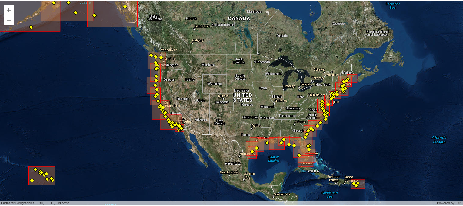
NWPS produces fields of integral wave parameters, wave spectra, and individually tracked wave
systems (Gerling-Hanson plots). Experimental rip current and total water level
guidance is produced at 5 pilot WFOs.
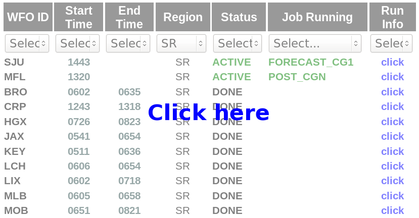
Access the NWPS Model Status Page
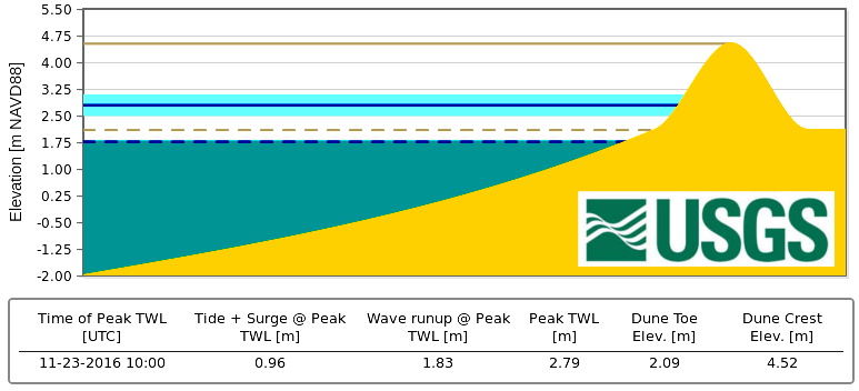
Coastal Hazards: Total Water Level Viewer
This tool displays experimental total water level and coastal
change model guidance for select regions of the U.S. coastline using
NWPS output and local beach characteristics (Courtesy of
U.S. Geological Survey)
Monthly Validation - Southern and Eastern Regions
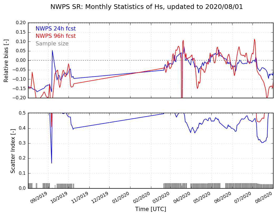
Below are the combined monthly validation statistics at all coastal data buoys in
the NWS Southern and Eastern Regions respectively, computed as a 30-day, moving-window
retrospective. For real-time validation, as well as buoy-specific
validation statistics, please see the model validation viewer above.
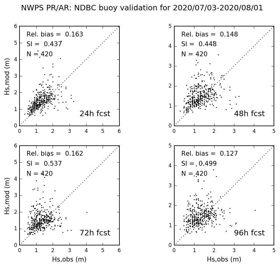
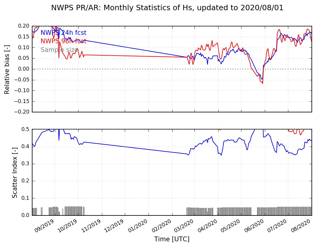
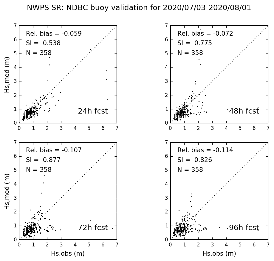 Southern Region Validation Statistics
Click to enlarge
|
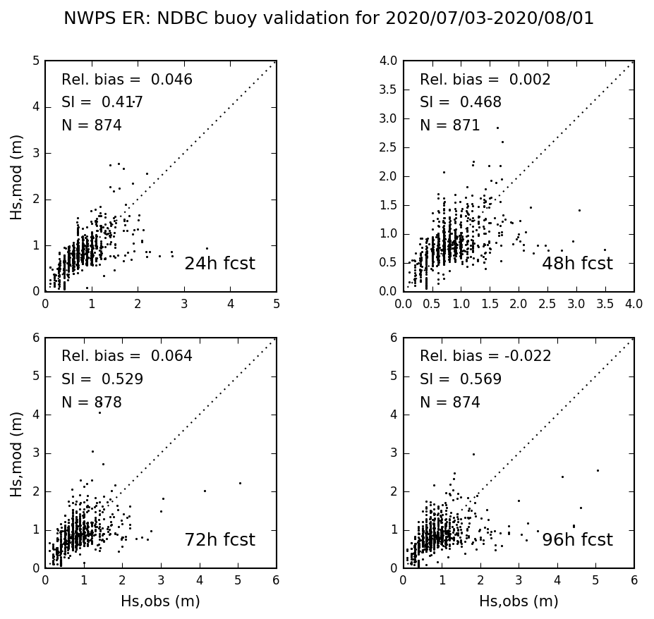 Eastern Region Validation Statistics
Click to enlarge
|
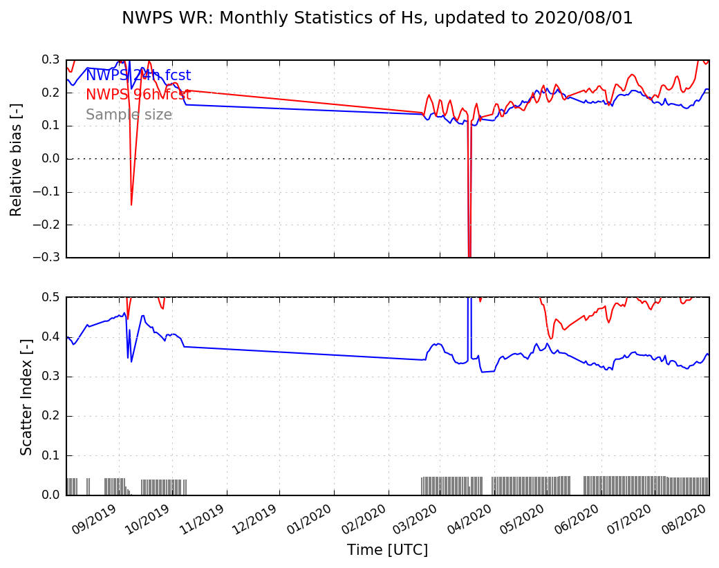
 Southern Region Statistics History
Click to enlarge
|
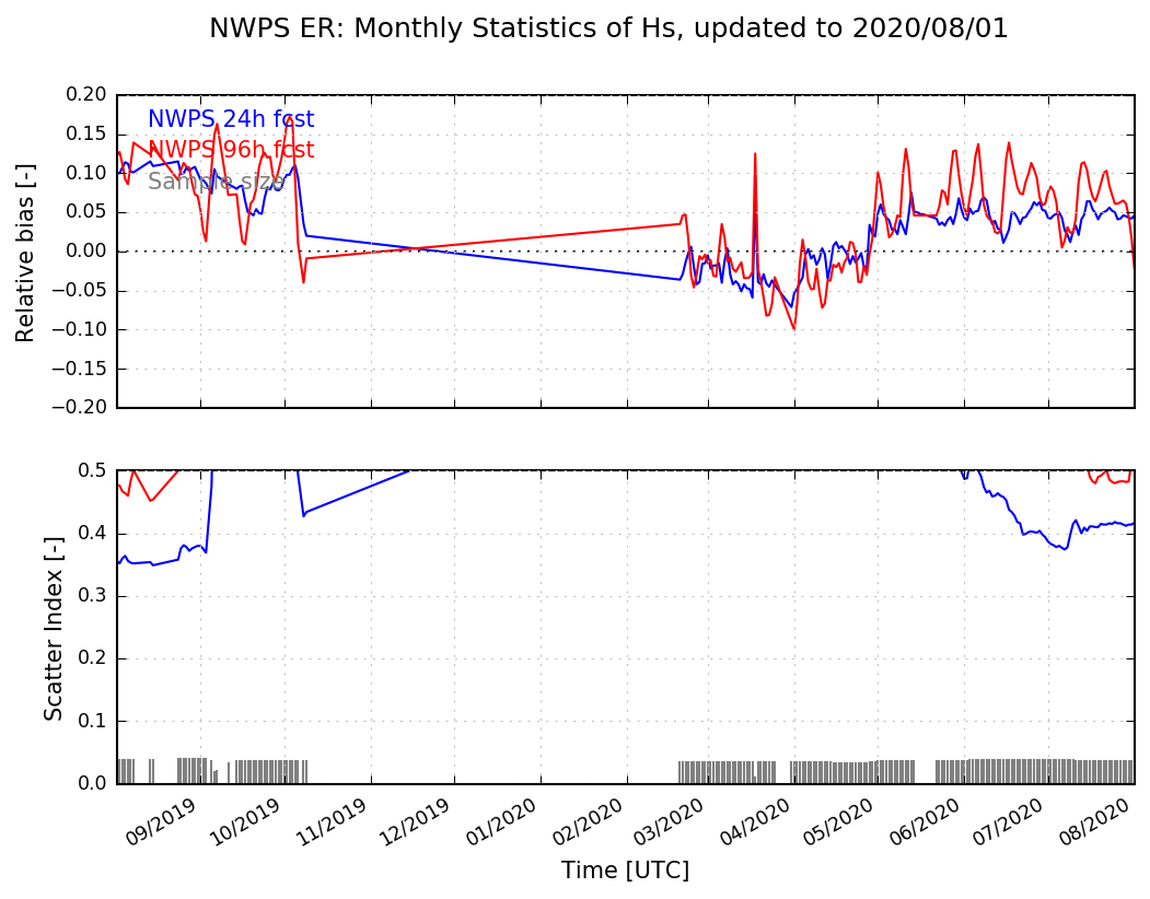 Eastern Region Statistics History
Click to enlarge
|
Monthly Validation - Western, Pacific and Alaska Regions
Below are the combined monthly validation statistics at all coastal data buoys in
the NWS Western, Pacific and Alaska Regions, computed as a 30-day, moving-window
retrospective. For real-time validation, please see the model validation viewer above.
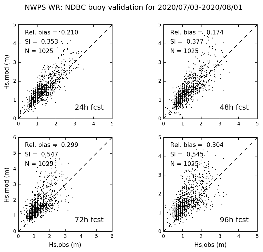 Western Region Validation Statistics
Click to enlarge
|
 Pacific/Alaska Region Validation Statistics
Click to enlarge
|
 Western Region Statistics History
Click to enlarge
|
 Pacific/Alaska Region Statistics History
Click to enlarge
|
Follow Us
Sign up for the
NWPS mailing list
for updates and information on this system.
Follow the system development on our Wiki Page
(authorization required).
References
Gibbs A., G. Dusek, A. J. van der Westhuysen, P. Santos, S. Stripling, S. Huddleston, E. Rivera-Acevedo, J. Estupinan, and H. Seim. Numerical Validation of a Coupled Probabilistic Rip Current Model and Nearshore Wave Prediction System for South Florida. Proc. 95th AMS Annual Meeting,
Am. Meteor. Soc., Phoenix, 2015. Available here
Dusek G., A. J. Van der Westhuysen, A. Gibbs, D. King, S. Kennedy, R. Padilla, H. Seim, and D. Elder. Coupling a Rip Current Forecast Model to the Nearshore Wave Prediction System. Proc. 94th AMS Annual Meeting,
Am. Meteor. Soc., Atlanta, 2014. Available here
Van der Westhuysen, A. J., A. A. Taylor, R. Padilla-Hernandez, A. Gibbs, P. Santos, D. Gaer, H. D. Cobb III, J. R. Lewitsky, and J. R. Rhome. Enhancements to the Nearshore Wave Prediction System to provide Coastal and Overland Hurricane Wave Guidance. Proc. 94th AMS Annual Meeting,
Am. Meteor. Soc., Atlanta, 2014. Available here
Van der Westhuysen, A. J., R. Padilla-Hernandez, P. Santos, A. Gibbs, D. Gaer,
T. Nicolini, S. Tjaden, E. M. Devaliere and H. L. Tolman. Development and validation
of the Nearshore Wave Prediction System. Proc. 93rd AMS Annual Meeting,
Am. Meteor. Soc., Austin, 2013. Available here
Gibbs, A., P. Santos, A. J. van der Westhuysen and R. Padilla-Hernandez.
NWS Southern Region Numerical Optimization and Sensitivity Evaluation in Non-Stationary
SWAN Simulations. Proc. 92nd AMS Annual Meeting, Am. Meteor. Soc.,
New Orleans, 2012. Available here
Settelmaier, J. B., A. Gibbs, P. Santos, T. Freeman, D. Gaer. Simulating
Waves Nearshore (SWAN) Modeling Efforts at the National Weather Service
(NWS) Southern Region (SR) Coastal Weather Forecast Offices (WFOs).
Proc. 91st AMS Annual Meeting, Am. Meteor. Soc., Seattle, 2011.
Available here
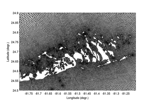
Upcoming features: Unstructured meshes
SWAN and WW3's unstructured grid functionality is currently being
incorporated into NWPS. With flexible unstructured grids, computational
time can be optimized by concentrating computational grid points only in
those nearshore regions where it is required to adequately resolve physical
processes at small spatial scales, as shown in the examples below. This
new functionality is scheduled for September 2017.
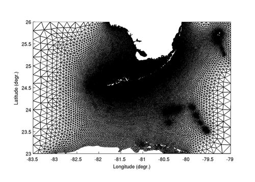 Unstructured mesh over WFO Key West domain.
Click to enlarge
|
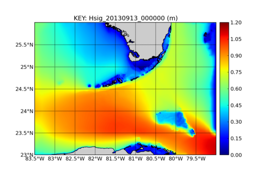 Forecast guidance produced using NWPS (with SWAN wave model).
Click to animate
|
 Zoom of unstructured mesh over Key West.
Click to enlarge
|
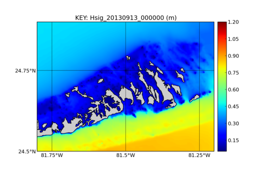 Forecast guidance over zoomed-in domain.
Click to animate.
|
-->
|


)
)
)
)
)
)
)
)
)
)
)
)