National Weather Service
Office of Climate, Water, and Weather Services
Technical Procedures Bulletin
Series No. 489
Created 02/05/2002; revised o4/07/2004.
Subject: NOAA Coastal Ocean Forecast System (COFS)
THIS IS A NEW PRODUCT
This bulletin, prepared by Ilya Rivin and Lawrence D. Burroughs, of the Environmental Modeling Center (EMC), James Partain of the Marine Prediction Center (MPC), and John G. W. Kelley of the National Ocean Service (NOS), describes a new coastal ocean forecast system for the U.S. East Coast. The system is based on the three-dimensional Princeton Ocean Model (POM) and produces a daily nowcast and forecast guidance out to 48 hours of water temperature, salinity, currents, and surface elevation for a region off the U.S. East Coast from approximately 30 to 47 N latitude and out to 50 W longitude. The spatial resolution of the model varies from approximately 20 km offshore to about 10 km near shore. In the vertical, a 19-level sigma (terrain-following) coordinate system is used with at least half the levels concentrated in the upper 100 m. Tidal forcing is included in the model. The model uses air-sea fluxes which are derived from NCEP's Eta mesoscale atmospheric forecast model. Sea surface temperature (SST) and sea surface height anomalies (SSHA) from observational data are assimilated every day.
The COFS will be implemented during spring of 2002. The forecast guidance will be issued daily with an issuance time of approximately 0300 UTC.
NOAA Coastal Ocean Forecast System
(COFS)
Ilya Rivin and Lawrence Burroughs (EMC)
James Partain (MPC)
John Kelley (NOS)
1.Introduction
The purpose of the NOAA Coastal Ocean Forecast System (COFS) is to generate daily nowcasts (i.e. analysis) and forecasts at 24 hour intervals out to 48-h of ocean properties for the coastal ocean of the United States East Coast. The development of COFS was started due to a growing demand for subsurface information as well as improved surface forecasts in coastal areas. COFS demand was recognized by the U.S. National Research Council which recommended that the nation establish an ``operational capability for nowcasting and forecasting currents, water temperatures and related fields to support coastal and offshore operations and management'' (National Research Council, 1989). Development of COFS for the U. S. East Coast began in 1991. Details of the development are found in Breaker and Rao (1998).
2. Description of COFS
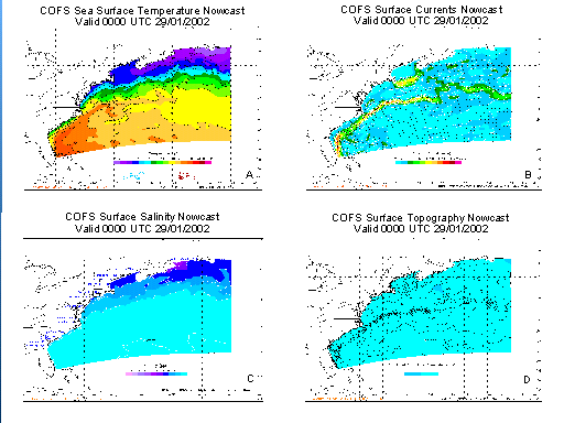
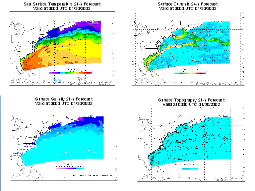
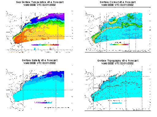
The COFS domain covers a region from the coastline of the U.S. east to 50oW longitude and from approximately 30o to 47oN latitude (see Fig. 1 ). The coastal boundary corresponds to the 10 m isobath on the continental shelf.
The basis of COFS is a 3D hydrodynamic finite difference, ocean circulation model which has been developed jointly by Princeton University, the National Ocean Service and the National Weather Service. The model commonly referred to as the Princeton Ocean Model (POM) produces 24-h simulations of water temperature, salinity, currents, and surface elevation. The horizontal spatial resolution varies from approximately 20 km off-shore to 10 km near-shore (Aikman et al., 1996).
The model bathymetry is derived from the U.S. Navy's Digital Bathymetric Data Base five minute grid (DBDB-5, National geophysical Data Center) and modified over the continental shelf with 15 second National Ocean Service bathymetry (NOS-15). See Fig. 1 .
The model is driven at its upper boundary by heat, moisture and momentum fluxes derived from NCEP's Eta mesoscale atmospheric forecast model. The ocean model is driven along its open (i.e. eastern and southern) boundaries by monthly climatological estimates of temperature and annual climatological estimates of salinity and transport. Monthly climatological estimates of fresh water input are prescribed on the model coastal boundary for 16 major East Coast rivers, bays, sounds or gulfs. COFS also includes astronomical tidal forcing along the open boundaries for tidal constituents and body forcing within the model domain.
At 24-hour intervals, satellite altimeter data (surface height anomalies, SSHAs) are assimilated with an optimal interpolation based algorithm. These data are input for correction of the model's sea surface height field and assimilation into the subsurface temperature and salinity fields by using correlation functions statistically derived from the model itself. Data from the prior 10-day orbital cycle are used in this analysis step.
COFS assimilates SST data, in-situ and remotely sensed, for the most recent 48 hours (Kelley et al., 2001). First, the SST data are assimilated variationally into top layer ocean temperature and then is projected into the deep ocean by a mixed layer extrapolation scheme.
3. Operational Procedure of Coastal Ocean Forecasting
The COFS cycle is currently triggered from the Eta 0000Z UTC cycle.
At 24-hour intervals, satellite altimeter data are assimilated with an optimal interpolation based algorithm from Princeton University. SSHAs derived from satellite altimeter data are provided by the NOAA Laboratory for Satellite Altimetry. These data are input for correction of the model's sea surface height field and assimilation into the subsurface temperature and salinity fields using correlation functions statistically derived from the model itself. Gulf Stream location data for the current day and TOPEX data from the prior 10-day orbital cycle, are used in this analysis step, which provides the input fields for the second analysis step.
Sea surface temperature (SST) data from in-situ and satellite observing platforms are assimilated into the updated fields from the first data assimilation step, in a nowcast/data assimilation cycle producing initial conditions for the 48-h forecast. In-situ observations are from fixed and drifting buoys, C-MAN stations, and ships. Remotely sensed observations are MCSST retrievals from the AVHRR sensor onboard the NOAA polar orbiting satellites. Surface atmospheric forcing is obtained from 3-hourly analyses of NCEP's Eta Data Assimilation System (EDAS).
The forecast cycle generates coastal ocean forecasts out to 48 hours at 24-h intervals. Surface forcing is obtained from the 3-hourly surface fields from NCEP's Eta mesoscale atmospheric prediction model.
4. Performance evaluation
The daily output is undergoing evaluation by forecasters from NCEP's Marine Prediction Center in Camp Springs, MD. In addition, COFS products were evaluated as part of the Coastal Marine Demonstration Project in June and July, 1999 and February and March, 2000 (Szilagyi, et al., 2000).
COFS products were evaluated as part of the Coastal Marine Demonstration Project in June and July, 1999 and February and March, 2000. Additionally, forecasters in NCEP's Marine Prediction Center (MPC) have been looking at the COFS output in various forms since 1998, principally to assist the COFS development effort. More recently, however, as the COFS system has matured, the MPC has begun using the COFS output to directly assist them in the routine production of Gulfstream North- and South-wall information for their graphical forecasts over the western Atlantic.
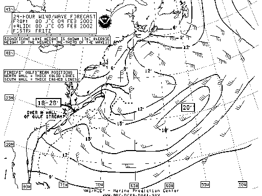
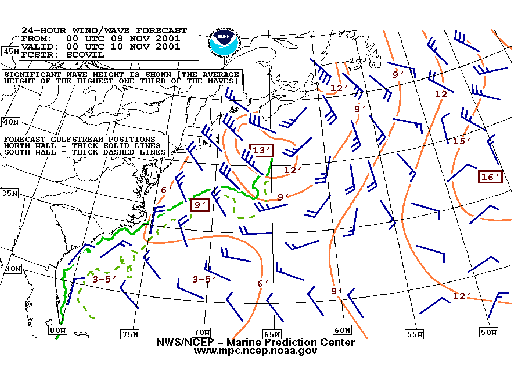
The MPC has a requirement to delineate areas on their 24-hour wind/wave forecast graphics (see Figs. 2 and 3 ) where local forecast conditions are expected to significantly deviate from the remainder of the forecast due to the presence of the Gulfstream. The COFS model assists the MPC in delineating those areas right along the Gulfstream's North-wall, the area most prone to extreme and rapid weather changes in unstable environments. Forecasters examine the surface current and SST fields from COFS to assist in the diagnosis of the 24-hour forecast position of various Gulfstream features, such as the North-wall.
5. Products and Dissemination
COFS products are three-dimensional fields of temperature, salinity and currents and a two-dimensional field of surface elevation.
All products are available in GRIB format at:
http://polar.ncep.noaa.gov/cofs/
Sometime in the future products will also be available on AWIPS in graphical formats. 24-h average and instantaneous fields are available to the research community through the National Oceanographic Data Center.
6. Concluding Remarks
In the MPC, forecasters have found the COFS model output to be quite helpful in their general diagnosis of the location of various forecast Gulfstream features, especially the Gulfstream North-wall. Forecasters have noted the reliability of the COFS Gulfstream features decreases with distance eastward from the US east coast, after the Gulfstream "separates" from the continental shelf. Nearer to the shelf, however, and southward along the Southeastern U.S. coastline, the COFS output has been much more reliable.
7. References
Aikman, F. III, G.L.Mellor, T.Ezer, D.Sheinin, P.Chen, L.Breaker, K.Bosley and D.B.Rao, 1996. Toward an operational nowcast/forecast system for the U.S. East Coast. In Modern Approaches to Data Assimilation in Ocean Modeling, P.Malanotte-Rizzoly (ed.), Elsevier Oceanography Series, 62, 347-376.
Breaker, L. C. and D. B. Rao, 1998: Experience gained during implementation of NOAA Coastal Forecast System. Proc., The Marine Technology Society Annual Conf., Baltimore, MD, The Marine Technology Society, 235-241.
Kelley, J.G.W., D. W. Behringer, H. J. Thiebaux, and B. Balasubramaniyan, 2002: Assimilation of SST into a real-time coastal ocean forecast system for the U.S. East Coast. Weather and Forecasting, in press.
National geophysical Data Center, 1985: Worldwide gridded bathymetry-DBDB5 5-minute latitude/longitude grid, data announcement 85-MGG-01, NOAA/NGDC, Boulder, Co.
National Research Council, 1989: Opportunities to Improve Marine Forecasting. Committee on Opportunities to Improve Marine Observations and Forecasting. Marine Board, Commission on Engineering and Technical Systems, National Research Council, Washington, DC, 125 pp.
Szilagyi, G. J., F. Aikman, and L. C. Breaker, 2000: Evaluation of the Coastal Marine Demonstration. NOAA Report, 39 pp.