Series No. 495
Subject: Wave Forecasting for Western North Atlantic Ocean and Adjacent Waters
SIGNIFICANT CHANGES FROM LAST BULLETIN ON THIS SUBJECT NO. 459
Created 06/04/2002; reviewed and revised 04/07/2004.
W/NP21: YYC, LDB, HLT
This bulletin, prepared by Y. Y. Chao, L. D. Burroughs, and H. L. Tolman of the Marine Modeling and Analysis Branch (MMAB), Environmental Modeling Center (EMC), National Centers for Environmental Prediction (NCEP), describes automated wave guidance for Western North Atlantic and adjacent waters in alphanumeric and Gridded Binary (GRIB) formats. This guidance was implemented operationally on the IBM mainframe computer in January 2000.
The WNA is based on the NOAA WAVEWATCH-III (NWW3) which is described in detail in Technical Procedures Bulletin (TPB) 494 (Chen, Burroughs, and Tolman 2003) and Tolman (2002). The NWW3 provides the boundary conditions to the WNA. The domain extends from 98.25oW to 29.75oW and from 0.25oS to 50.25oN with a grid resolution of 0.25o by 0.25o in latitudinal and longitudinal directions.
Various graphics and text products for the WNA are available at http://polar.ncep.noaa.gov/waves/, and available for anonymous ftp at ftp://polar.ncep.noaa.gov/pub/waves.
The following wind and wave parameters are available in GRIB format at the web site above and on AWIPS as GRIB bulletins: Hs, Dm, Tm, peak wave period and direction, wind sea peak period and direction, wind speed and direction, and u- and v-wind components.
Spectral text bulletins for the WNA are available at the web site above. These files are in ASCII and are available by anonymous at the ftp site above. These bulletins have been implemented on AWIPS, but with a condensed format necessitated by the capabilities of the communications gateway and display capabilities of AWIPS.
The WNA wave guidance is generated four times daily out to 168 hours based on the 0000, 0600, 1200 and 1800 UTC cycles of the Global Forecast System.
Technical Procedures Bulletin No. 459 is now operationally obsolete.
WAVE FORECASTING FOR THE WESTERN NORTH ATLANTIC
and
ADJACENT WATERS(1)
By
Y.Y. Chao, L.D. Burroughs, and H.L. Tolman(2)
In order to predict wave conditions adequately over the continental shelf and near land boundaries, a regional model which has higher resolution in grid space and possibly in spectral components is required. The regional model also must calculate rigorously the effects of submarine bottom conditions and any currents which may exist on wave growth, transformation and dissipation. A global-scale wave model usually is designed only to provide the general wave pattern over the deep ocean. It does not provide information accurate enough to describe small-scale, complex wave patterns near the coastal areas.
The Western North Atlantic (WNA) regional wave model was designed to fill the needs of the Eastern and Southern Regions, the Ocean Prediction Center (OPC) and the Tropical Prediction Center (TPC) which had requested that the domain of the model be from 50oN south to the Equator and from the coast of the Americas east to 30oW with the entire Caribbean Sea included. The boundary conditions are provided by the NOAA WAVEWATCH III (NWW3).
The WNA was implemented in January 2000 and is based on the NWW3 which is described in detail in Technical Procedures Bulletin (TPB) 494 (Chen, Burroughs, and Tolman 2003) and Tolman (2002). The NWW3 provides the boundary conditions to the WNA. Its domain extends from 98.25oW to 29.75oW and from 0.25oS to 50.25oN with a grid resolution of 0.25o by 0.25o in the latitudinal and longitudinal directions.
The following wind and wave parameters are available in GRIB format at the web site below and on AWIPS as GRIB bulletins: Hs, Dm, Tm, peak wave period and direction, wind sea peak period and direction, wind speed and direction, and u- and v-wind components.
These graphics and text products for the WNA are available at http://polar.ncep.noaa.gov/waves/. The text files are in ASCII and are available by anonymous at ftp://polar.ncep.noaa.gov/pub/waves/date.cycle,
where date represents the date in yyyymmdd format and cycle represents the run cycle identifier (t00z, t06z, t12z or t18z, respectively). These bulletins have been implemented on AWIPS, but with a condensed format necessitated by the capabilities of the communications gateway and display capabilities of AWIPS. See fig. 1 for a sample bulletin and Table 1 for the list of points having spectral wave bulletins, their locations, and their bulletin headers.
The WNA wave guidance is generated four times daily out to 168 hours based on the 0000, 0600, 1200 and 1800 UTC cycles of the Global Forecast System (GFS; Kanamitsu et al. 1991 and Caplan et al. 1997).
2. Model Description
Regional wave forecasts for Western North Atlantic and adjacent waters are generated at NCEP by using the WNA model. Fields of directional frequency spectra in 24 directions and 25 frequencies are generated at one hour intervals up to 168 hours. The 24 directions begin at 90 degrees to the east and have a directional resolution of 15 degrees. The 25 frequencies used by the WNA are given by bin in Table 2.
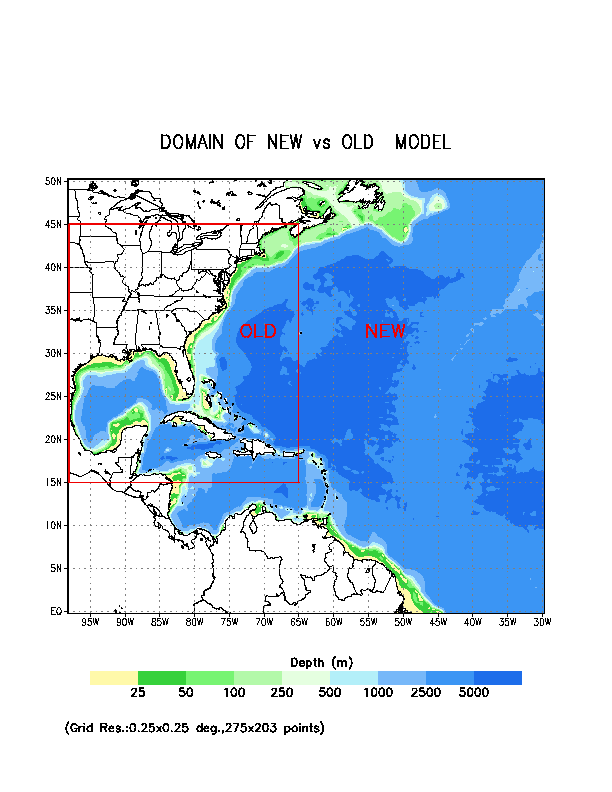
Figure 2 shows the domain of interest and the depth field which is derived from bathymetric data available from the National Geophysical Data Center. Required input wave spectral data for the boundary grid points of the WNA are obtained by linearly interpolating the spectra of neighboring grids of the NWW3. The wind fields driving the model are obtained from the output of NCEP's operational Global Data assimilation System (GDAS) and the GFS. The wind fields are constructed directly from spectral coefficients of the lowest sigma level at 0.5o x 0.5o longitude and latitude resolution, and are interpolated to the resolution of the wave model grid. They are converted to 10 m winds by using a neutrally stable logarithmic profile. Air and sea temperature data are obtained from the lowest sigma level air temperatures of the GFS and the sea surface temperature available in the model are used in the model wave growth parameterization. Finally, the wave model incorporates a dynamically updated ice coverage field in the region. These data are obtained from NCEP's operational automated passive microwave sea ice concentration analysis (Grumbine 1996; updated daily). Ocean currents are not considered in the model at the present.
The model runs four times daily for the 0000, 0600, 1200 and 1800 UTC cycles. GDAS wind fields from the previous 12 hours at 3-h intervals (analyses and 3-h forecasts) are used for a 12-h wave hindcast. Winds from the GFS at 3-h intervals out to 168 hours are used to produce wave forecasts up to 168 hours at hourly intervals.
3. Performance Evaluation
The WNA was extensively evaluated prior to its implementation in January 2000 and continues to be evaluated on a regular basis. It has been consistently shown to have less error and higher correlation with observations than similar models.
4. Available Products and Dissemination
The following wind and wave parameters are available in GRIB format at ftp://polar.ncep.noaa.gov/pub/waves, and became available on AWIPS in software build 5.2.2: Hs, Dm, Tm, peak wave period and direction, wind sea peak period and direction, wind speed and direction, and u- and v-wind components. Spectral text bulletins are also available on the web at the site above and are on AWIPS.
a. GRIB bulletins
GRIB bulletins became available for use in AWIPS with software build 5.2.2. Table 3 gives the bulletin headers and their meaning. Bulletins are available at 6-h intervals from 00- through 72-h and at 12-h intervals from 72- to 168-h. Available parameters are Hs, Dm, Tm, peak wave period and direction, wind sea peak wave period and direction, and u and v components of the wind velocity. A 0.25 x 0.25 degree lon./lat. grid is used with a domain from 98.25oW to 29.75oW and from 0.25oS to 50.25oN.
b. Alphanumeric spectral messages for the INTERNET
Spectral text bulletins are presented for numerous points of the WNA. These bulletins are in ASCII and are available on the INTERNET, and, in AWIPS (see section c for a description of that format). The line length of the table is 130 characters by 100 lines. The header of the table identifies the output location, the generating model and the run date and cycle of the data presented. At the bottom of the table, a legend is printed. The table consists of 8 columns. The first column gives the time of the model results with a day and hour (the corresponding month and year can be deduced from the header information). The second column presents the overall significant wave height (Hs), the number of individual wave fields with a wave height over 0.15 m that could not be tracked in the table (x). Individual wave fields in the spectrum are identified by using a partitioning scheme similar to that of Gerling (1992). In the remaining six columns individual wave fields identified with their wave height (Hs), peak wave period (Tp) and mean wave direction (dir, direction in which waves travel relative to North). Generally, each separate wave field is tracked in its own column. Such tracking, however is not guaranteed to work all the time. An asterisk (*) in a column identifies that the wave field is at least partially under the influence of the local wind, and, therefore, most likely part of the local wind sea. All other wave fields are pure swell.
c. Spectral text bulletins for AWIPS
The format for the spectral text bulletins sent to AWIPS is generally the same as that for the web, except that the period is to the nearest second, the wave heights are to the nearest foot, the direction is from (meteorological, rather than oceanographic), the number of fields that could not be tracked is not given, and the asterisk indicating when a wave field is, at least, partially under the influence of the local wind is not shown. The bulletin width is 69 characters, which is a legacy of the teletype era and the display capability of AWIPS. A sample bulletin is shown in fig. 1 and the list of points for the NWW3 is given in Table1.
5. References
Booij, N. and L.H. Holthuijsen, 1987: Propagation of ocean waves in discrete spectral wave models. J. Comput. Phys., 68, 307-326.
Caplan, P., J. Derber, W. Gemmill, S,-Y. Hong, H.-L. Pan and D. Parish, 1997: Changes to the NCEP operational medium-range forecast model analysis/forecast system. Wea. Forecasting, 12, 581-594.
Chalikov, D.V. and Belevich, M.Y., 1993: One-dimensional theory of the boundary layer. Boundary-Layer Meteor., 63, 65-96.
Chao, Y.Y., 1997: The U.S. East Coast-Gulf of Mexico wave forecasting model Technical Procedures Bulletin No. 446, National Weather Service, NOAA, U.S. Department of Commerce, 10 pp. [Available at http://polar.ncep.noaa.gov/mmab/tpbs/obsolete.tpbs/wnatpb/wnatpb.html; OBSOLETE]
Chen, H.S., L.D. Burroughs and H.L. Tolman, 2003: Ocean Surface Waves. Technical Procedures Bulletin No. 494, National Weather Service, NOAA, U.S. Department of Commerce. [Available at http://polar.ncep.noaa.gov/mmab/tpbs/operational.tpbs/tpb494/tpb494.htm]
Gerling, T.W., 1992: Partitioning sequences and arrays of directional wave spectra into component systems. J. Atmos. Ocean. Technol., 9, 444-458.
Grumbine, R.W., 1996: Automated passive microwave sea ice concentration analysis at NCEP. Ocean Modeling Branch Tech Note No. 120, NCEP, National Weather Service, NOAA, U.S. Department of Commerce, 13 pp.
Kanamitsu, M., J.C. Alpert, K.A. Campana, P.M. Caplan, D.G. Deaven, M. Iredell, B. Katz, H.-L. Pan, J.E. Sela and G. H. White, 1991: Recent Changes implemented into the global forecast system at NMC. Wea. Forecasting, 6, 425-435.
Tolman, H.L. and D. Chalikov, 1996: Source terms in a third-generation wind-wave model. J. Phys. Oceanogr., 26, 2497-2518.
Tolman, H.L., 2002: User manual and system documentation of WAVEWATCH-III version 2.2.2. Technical Note No. 222, Ocean Modeling Branch, NCEP, National Weather Service, NOAA, U.S. Department of Commerce, 139 pp. [Available at http://polar.ncep.noaa.gov/mmab/papers/tn222/MMAB_222.pdf].