Created 10/23/1997;superceded 08/17/1999.
Technical Procedures Bulletin 446
SUBJECT: THE U.S. EAST COAST-GULF OF MEXICO WAVE FORECASTING
MODEL
This bulletin, prepared by Dr. Y. Y. Chao of the Ocean Modelling Branch, Environmental Modelling
Center, National Centers for Environmental Prediction, describes a new regional ocean wave model
which encompasses the East Coast of the United States, the Gulf of Mexico, and portions of the
northern Caribbean Sea. This model replaces the old Gulf of Mexico wave model and expands the area
of interest to the East Coast of the United States.
The AFOS and DIFAX products for the Gulf of Mexico will continue until superceded by AWIPS, but with
output from the new model. Also, bulletins in WMO GRIB format will be sent to AWIPS, Family of
Services and the Global Telecommunications System. These bulletins will be available twice a day.
The bulletin headers are:
- OQK(A,C,E,G,I-M)98 ECOGM 10 m wind speed
- ORK(A,C,E,G,I-M)98 ECOGM 10 m wind direction
- OCK(A,C,E,G,I-M)88 ECOGM total significant wave height
- OJK(A,C,E,G,I-M)88 ECOGM period of spectral peak of the total wave spectrum
- OKK(A,C,E,G,I-M)88 ECOGM mean direction of the total wave spectrum
- OMK(A,C,E,G,I-M)88 ECOGM mean period of the total wave spectrum
- ONK(A,C,E,G,I-M)88 ECOGM mean direction of wind waves
- OOK(A,C,E,G,I-M)88 ECOGM significant height of swell waves
- OPK(A,C,E,G,I-M)88 ECOGM mean direction of swell waves
- OYK(A,C,E,G,I-M)88 ECOGM mean period of swell waves
where A, C, E, G, I-M stand for the 00-, 06-, 12-, 18-, and 24- through 48-h projections at 6-h intervals.
Comments and suggestions regarding product formats or the adequacy of model forecasts are welcome.
Please send questions to Yung Y. Chao Yung.Chao@noaa.gov
This Technical Procedures Bulletin supersedes TPB 381, which is now operationally obsolete.
The U.S. East Coast-Gulf of Mexico
Wave Forecasting Model
Y. Y. Chao
OMB Contribution Number 149
1. Introduction
A high grid-resolution third generation wave forecasting system has been developed for the east coast
of the United States and the Gulf of Mexico. The general objective of this system is to complement
predictions of the present operational global wave model (NOAA/WAM, Chen 1995) for the Atlantic
coastal areas and to replace the operational wave model for the Gulf of Mexico (GMEX, Chao 1991).
Since the present global model has a grid resolution of 2.5 deg. by 2.5 deg., the resulting predictions
can not describe wave conditions over the coastal areas with sufficient detail. Because the present Gulf
of Mexico model is a second generation model and does not consider waves propagating into the gulf
from the Atlantic Ocean or the Caribbean Sea (It assumes the gulf is a closed basin.), it cannot predict
realistic hurricane wave conditions in the gulf. A particular objective is to use the East Coast and Gulf of
Mexico (ECOGM) model as a basis to provide forecast guidance for selected locations along the east
coast and the gulf coast where detailed description of wave fields are required. Providing forecast
guidance for the yachting venue of the 1996 Summer Olympic Games off Savannah, Georgia is a
specific example.
In order to satisfy the above-mentioned objectives within the constraints of computational economy and
computer memory, a model which is capable of handling multiple grids must used. Furthermore, in view
of the frequent occurrence of hurricanes and extra-tropical cyclones which affect the east coast and the
gulf areas, the wave model must also provide adequate descriptions of the sea state under rapidly
varying weather conditions. In addition, consideration has to be given to the effects of water depth and
ocean currents on the transformation of surface waves. At present, the WAM model readily meets these
requirements. The capabilities of the WAM model have been assessed in SWAMP (1985), SWIM
(1985), WAMDI (1988) and Komen et al (1994). The model currently provides global ocean wave
forecasts at NCEP.
2. The Wave Forecasting System
The system employs the WAM model Cycle-4 version software package (GÅnther, Hasselmann and
Janssen, 1991). The model solves the energy balance equation for the frequency-direction surface
wave spectrum. We have assumed that the water surface elevation is not a function of time, and there
are no currents involved (e.g., ignoring the existence of the Gulf Stream). Thus, the physics of the
energy balance equation involves mainly spherical propagation, shoaling and depth refraction, bottom
dissipation, wind forcing, white capping, and wave-wave interactions.
The system consists of three grids named A-, B-, and C-grid. The A-grid has a grid size of 1 deg. by 1
deg. It covers the Atlantic Ocean from latitude 78 deg. S to 78 deg. N and from longitude 100 deg. W to
35 deg. E. The purpose of this grid is to simulate swell which may propagate to the area of interest
from far north and far south in the model domain. It also provides boundary conditions for the B-grid.
The B-grid extends from 98 deg. W to 65 deg. W and from 15 deg. N to 45 deg. N. It covers the east
coast, the Gulf of Mexico and the northern portion of the Caribbean Sea. The purpose of including the
Caribbean Sea is to simulate hurricane waves generated in the region entering the gulf through the
Yucatan Channel. The grid size is 1/4 deg. by 1/4 deg. A C-grid area extends from land to 76 deg. W
and from 25 deg. N to 35 deg. N stretching from the tip of Florida to Cape Hatteras enclosing the
Savannah waters. The grid resolution is 1/12 deg. by 1/12 deg. This grid was used for the Olympics
in 1996 and can be moved to different locations for special purposes, but is not intended for normal
operational use.
The prognostic part of the wave spectrum has 25 frequencies and 12 directions (30 deg. resolution) for
all grids. The frequency is determined according to the logarithmic scale: f(m)=1.1f(m-1), where f, is the
frequency, and m is the band number of the frequency. The minimum frequency (corresponding to the
first frequency band, f(1) ) is given to be 0.042 Hz. While the maximum frequency is 0.411 Hz. The
computational time step for the source term is the same as the propagation term; for A-grid, the time
step is 20 minutes, for B- and C-grid, 5 minutes and 3 minutes are used, respectively.
The required input data includes water depth and wind fields. The gridded depth fields are derived
from bathymetry data of 5-minute grid-spacing obtained from the National Geophysical Data Center.
Input wind fields, at 10 meters above the mean sea level, are obtained from NCEP's operational
atmospheric models: the Global Atmospheric Spectral Model - Aviation Run (AVN) (Kanamitsu, et al.
1991) specified at one degree intervals for A-grid and the regional meso-eta model which has a grid
resolution of 29 km (Black 1994) for B- and C-grids. Wind data are given at three hour intervals up to
36 hours.
The system runs twice daily using wind data from AVN run at 00Z (and 12Z) and from meso-eta model
run at 03Z (and 15Z). Each cycle produces up to 36 hour forecasts at three hour intervals. For A-grid,
a 12 hour hindcast is performed by using analyzed wind fields to provide initial wave fields for the
forecast.
3. Evaluation of Forecast Results
Trial operational runs of the system involving all three grids have been made since July 1996. An
evaluation of system performance against buoy measurements also has been made. In this section we
begin by presenting a case study for July 1996. Several significant marine weather related events
occurred during the month which caused great concern of wave condition in the region. First, Hurricane
Bertha swept through the east coast in mid-July. Second, TWA Flight 800 crashed off the Long Island
coast on the 17th. Third, the yacht races of the 1996 Summer Olympics took place off the Savannah
coast from July 22 to August 2. Next, we present wind and wave conditions caused by an extra-tropical
storm - 1997 Easter storm, in contrast with the tropical storm - Hurricane Bertha. Finally, we present the
error statistics of the performance of new model in comparison with existing global and regional models
by using model and buoy data for a period of about a year during the years 1996 and 1997.
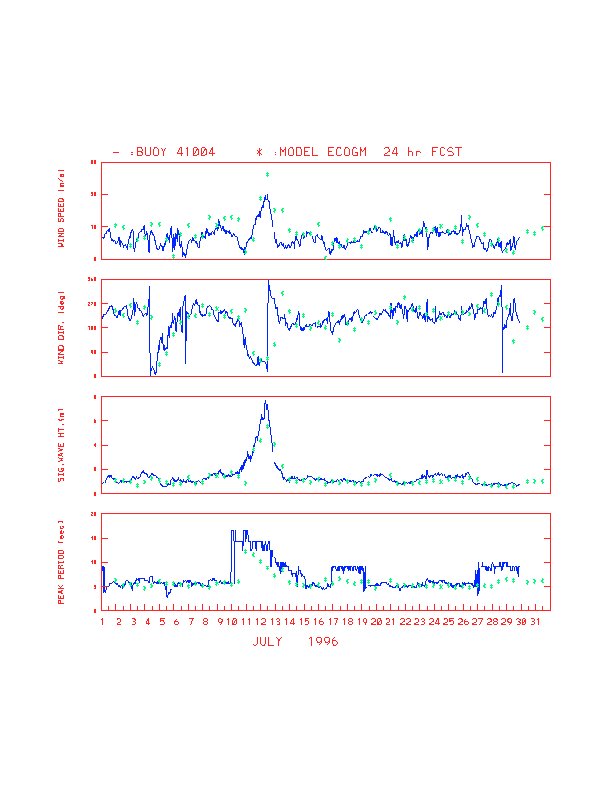
Figure 1 shows time series plots of the wind speed, wind direction, significant
wave height and peak wave period measured at NDBC buoy station 41004 and corresponding
parameters from B-grid model (denoted as ECOGM) output for 24 hour forecasts for July 1996. Buoy
41004 is located offshore from the Summer Olympic site for yacht racing. The rise of high waves shown
in the time series corresponds to the time when Hurricane Bertha swept over the east coast. Similar
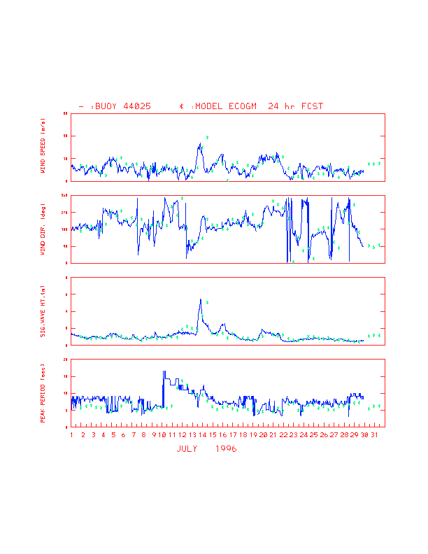
displays for NDBC buoy station 44025 are shown in Fig. 2. Buoy 44025 is
located off the southern shore of Long Island near the location where TWA Flight 800 crashed at about
00Z, July 18th (corresponding to 8:00 p.m. July 17th local time). In general, as can be seen from these
figures, the model wave height agrees with the observed trend, even though Eta29 model wind speeds
appear to be slightly over predicted, particularly when the hurricane was nearby. The model wave
periods, however, are lower than observed most of the time.
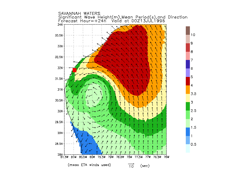
Figure 3 shows the 24 hour forecast of wave pattern, including the wave height
contour, and mean wave period and direction off Savannah waters, in response to the hurricane Bertha
generated wind field. The circular pattern of wave direction and low wave height in the vicinity of the
hurricane center can be clearly observed.
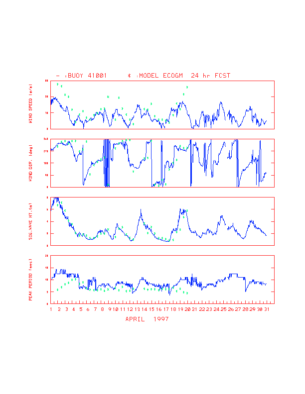
Figure 4 displays time series of observed and 24 hour forecast of wind and wave
conditions for April 1997 at buoy station 41001. The station is located at 34.8 deg. N 72.5 deg. W and
shows highest wave heights of all east coast buoys. Strong winds with wind speeds as high as 40 knots
and high waves with heights of more than eight meters are associated with an extra-tropical storm. The
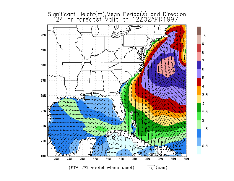
agreement between observed and predicted wave height undulations is excellent. Figure 5 is an example showing the associated 24 hour forecast wave pattern over
coastal waters near Cape Hatteras.
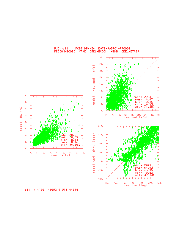
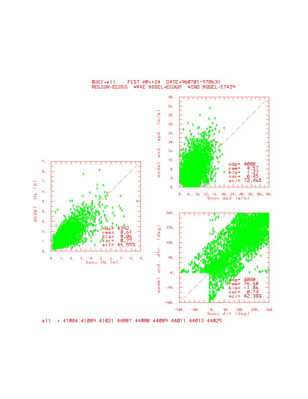
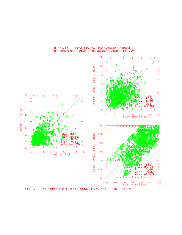
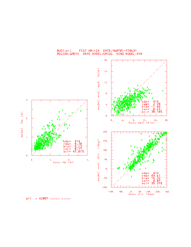
Figure 6a shows the scatter plots and error statistics of the significant wave
height (Hs), wind speed (spd) and wind direction (dir) from the year long ECOGM model and buoy data.
These statistics include the root mean square error (rms), mean bias error (bis), correlation coefficient
(cor), and scatter index (sci) and were calculated based on the available number of data points (ndp). In
the figure, ECOSD represents the use of data at buoy stations in the east coast deep water which has a
water depth of greater than 100 meters. The names of buoy stations are also identified in the figure.
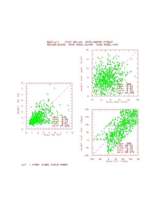
Similar data are shown in Fig. 6b for the existing global wave model GLWAM
(officially, NOAA/WAM). It can be seen that the new model (ECOGM) provides better wave height
forecasts for the offshore region of the east coast than the global model. A Similar statement can be
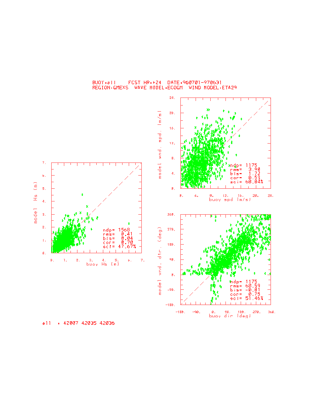
made for the shallow water (less than 100 meter) portion of the east coast as shown in Fig. 7a and Fig. 7b for ECOGM and GLWAM, respectively.
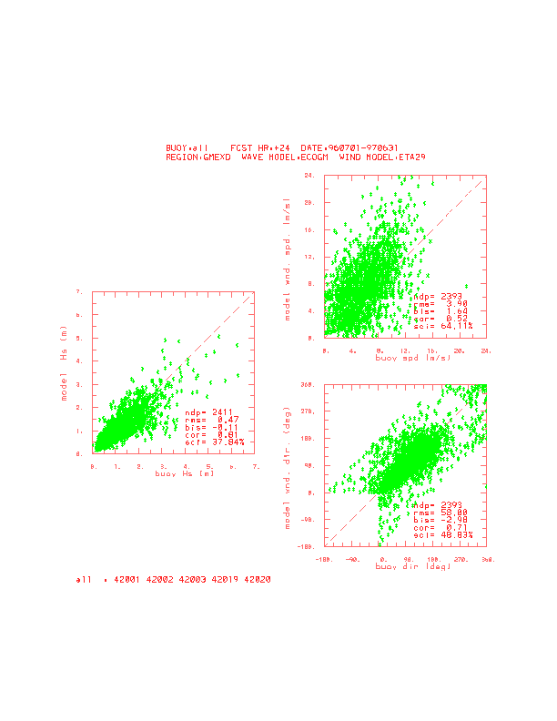
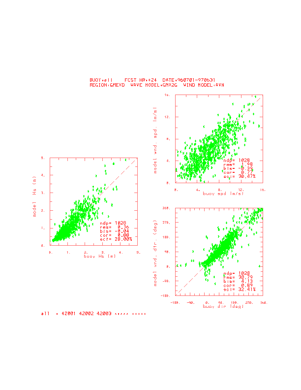
In the Gulf of Mexico, there seems to be no distinct difference in the error statistics between the new
model and the existing operational model GMX2G (officially, GMEX). Scatter plots for two model
forecasts are shown in Fig. 8a and Fig. 8b for the deep
water region and Fig. 9a and Fig. 9b for shallow water. It
should be noted, however, that the period of statistical study is limited to the winter and spring seasons
so that no rapidly changing wind conditions such as hurricane winds are involved. As such, the strength
of GMX2G, appropriate for a closed basin and relatively steady wind conditions, is fully used. In
contrast, the strength of new model in treating hurricane generated waves has not been taken
advantage of. It is expected that with the opening of connections to the Atlantic Ocean and the
Caribbean Sea, more realistic prediction of hurricane generated waves in the gulf can be achieved with
the new model as demonstrated during hurricane Bertha.
4. Model Products
The ECOGM model products for the Gulf of Mexico will include the current suite of DIFAX and AFOS
products until these communications modes are superseded by AWIPS. These products include
forecasts of the frequency directional spectrum, significant wave height associated with the total
spectrum energy, significant wave heights of the wind-sea and swell, mean periods of wind-sea and
swell at each grid point at 12-h intervals from 00 - 36 hours. When the 32 km early eta model becomes
available, these will again extend to 48 hours.
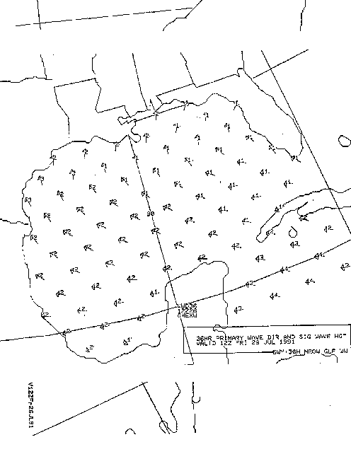
On AFOS, only the significant wave height of the total energy and the prevailing wave direction (either of
the wind-sea or swell) at selected grid points are transmitted. Figure 10 presents
a sample AFOS chart. The arrows indicate the prevailling wave directions and the numerical values
next to them indicate the total significant wave height in feet. These charts are transmitted twice daily at
approximately 0515 UTC and 1735 UTC under the AFOS headers listed below.
- NMCGPH6TY 00H GMX SWH PDR
- NMCGPH6UY 12H GMX SWH PDR
- NMCGPH6VY 24H GMX SWH PDR
- NMCGPH6WY 36H GMX SWH PDR
- NMCGPH6ZY 48H GMX SWH PDR Available when 32 km eta becomes available
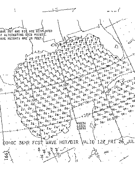
On DIFAX, a similar graphic is used, with the same data being displayed at an increased density of
grid points as compared to the AFOS plots. A five panel chart depicting wave direction and wave
heights is sent out twice a day at 0708 UTC (slot D0140) and at 1827 UTC (slot D184). Each panel
deicts the forecast guidance for 00-, 12-, 24-, 36-, and 48-h, respectively. Figure
11 shows a sample DIFAX chart. The 48-h panel will be blank until the 32 km resolution early eta
is implemented at which time the 48-h chart will be restored.
The model data will also be available as GRIB bulletins. The data will be sent on a regional 0.25 x
0.25 deg. longitude/latitude grid covering the area of the ECOGM. These data will be sent to Family of
Services, Global Telecommunications System, and AWIPS. The fields will be decoded on AWIPS and
displayed as desired. These charts are also available at the OMB web site on internet.
(http://polar.ncep.noaa.gov/regional.waves) The bulletin headers are listed below:
- OQK(A,C,E,G,I-M)98 ECOGM 10 m wind speed
- ORK(A,C,E,G,I-M)98 ECOGM 10 m wind direction
- OCK(A,C,E,G,I-M)88 ECOGM total significant wave height
- OJK(A,C,E,G,I-M)88 ECOGM period of spectral peak of wave spectrum
- OKK(A,C,E,G,I-M)88 ECOGM mean direction of the total wave spectrum
- OMK(A,C,E,G,I-M)88 ECOGM mean period of the total wave spectrum
- ONK(A,C,E,G,I-M)88 ECOGM mean direction of wind waves
- OOK(A,C,E,G,I-M)88 ECOGM significant height of swell waves
- OPK(A,C,E,G,I-M)88 ECOGM mean direction of swell waves
- OYK(A,C,E,G,I-M)88 ECOGM mean period of swell waves
where A, C, E, G, I-M stand for the 00-, 06-, 12-, 18-, and 24- through 48-h projections at 6-h
intervals.
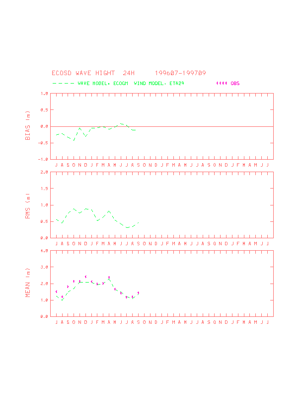
5. Concluding Remarks
Trial operational runs of the newly developed wave forecast system for the east coast and the Gulf of
Mexico - ECOGM model have been made. The results of a comparison of model output against buoy
measurement has shown that the system, in general, can produce adequate sea state forecasts for the
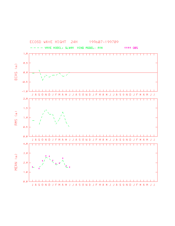
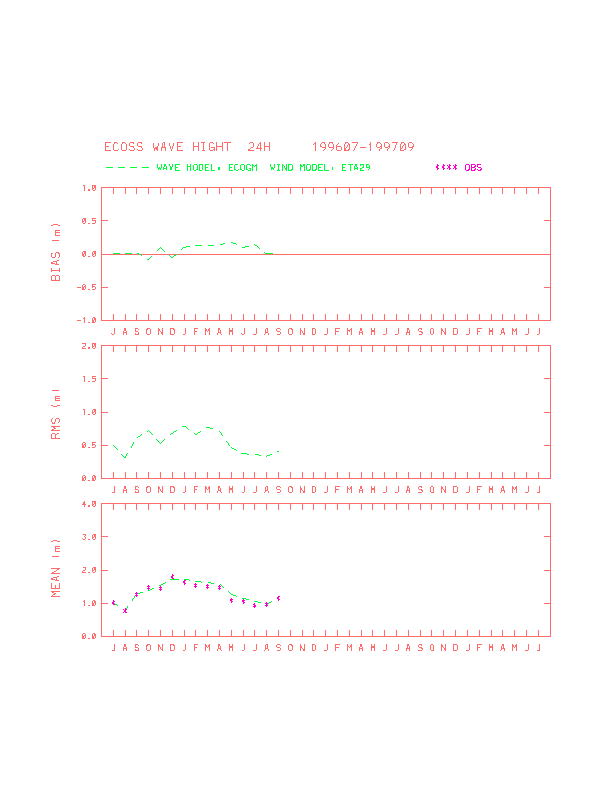
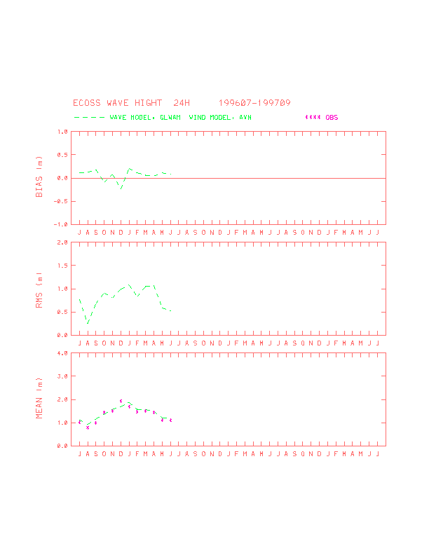
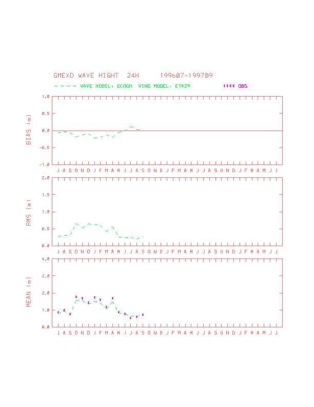
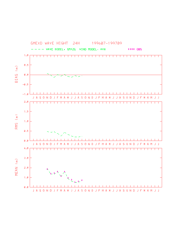
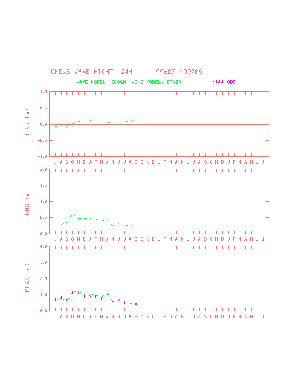
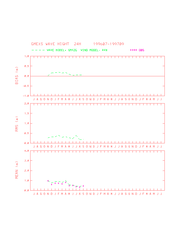
east coast of the United States and the Gulf of Mexico as well. Figures 12 to
15 summarize the model performance by comparing about a year long monthly mean bias and root
mean square errors of the new model and the existing global (GLWAM) and regional (GMX2G) models.
Based on these results, the following statements can be made:
- (1) ECOGM is superior to GLWAM for the east coastal waters under both normal and extreme wind
conditions.
- (2) ECOGM is comparable to GMX2G for the Gulf of Mexico under normal wind conditions and will
be better than GMX2G if improved EDAS is used to initialize ETA model winds.
- (3) For hurricane wind conditions, ECOGM is superior to GMX2G, because the former has better
model physics and boundary specifications.
References
- Black, T. L.,1994: The New NMC mesoscale eta model: Description and forecast examples.
Wea. Forecasting, 9, 265-278.
- Chao, Y. Y.,1991: The Gulf of Mexico spectral wave forecast model and products. TPB
No.381, National Weather Service, NOAA, U.S. Department of Commerce, 4pp.
- Chen, H. S., 1995: Ocean surface waves. TPB No.426, National Weather Service, NOAA,
U.S. Department of Commerce, 17pp.
- Gunther, H., S. Hasselmann and P.A.E.M. Janssen, 1991: The WAM Model Cycle 4. Tech.
Rept. 4, Deutsches Klimarechenzentrum, Hamburg, 91pp.
- Kanamitsu, M., J. C. Alpert, K. A. Campana, P. M. Caplan, D. G. Deaven, M. Iredell, B. Katz, H.-L.
Pan, J. Sela and G. H. White, 1991: Recent Changes Implemented into the Global Forecast System at
NMC. Wea. Forecasting, 6, 425-435.
- Komen, G. J., L. Cavaleri, M. Donelan, K. Hasselmann, S. Hasselmann and P. A. E. M. Janssen,
1994: Dynamics and Modeling of Ocean Waves, Cambridge University Press, Cambridge. 532
pp.
- SWAMP group, 1985: An intercomparison study of wind wave prediction model, part 1: Principal
Results and Conclusions, in: Ocean Wave Modeling; Plenum, New York, 256 pp.
- SWIM group, 1985: Shallow water intercomparison of wave prediction models (SWIM). Quart J.
Roy. Meteor. Soc., 111, 1087-1113.
- WAMDI group, 1988: The WA model - a third generation ocean wave prediction model. J.
Phys. Oceanogr, 18, 1775 -1810.
Figures and Captions
- Fig. 1 Time series of wind and wave parameters of 24-hr model forecasts (*
mark) and buoy measurements (solid line) at NDBC station 41004 for July 1996.
- Fig. 2 Time series of wind and wave parameters of 24-hr model forecasts (*
mark) and buoy measurements (solid line) at NDBC station 44025 for July 1996.
- Fig. 3 An example of 24-hr forecast of wave pattern caused by Hurricane
Bertha 1996.
- Fig.4 Time series of wind and wave parameters of 24-hr model forecasts (*
mark) and buoy measurements (solid line) at NDBC station 41001 for July 1996.
- Fig. 5 An example of 24-hr forecast of wave pattern caused by Easter storm
1997.
- Fig. 6a Scatter plots and statistics of the new model for the east coast deep
water.
- Fig. 6b Scatter plots and statistics of the existing global wave model for the
east coast deep water.
- Fig. 7a Scatter plots and statistics of the new model for the east coast
shallow water.
- Fig. 7b Scatter plots and statistics of the existing global wave model for the
east coast shallow water.
- Fig. 8a Scatter plots and statistics of the new model for the Gulf of Mexico
deep water.
- Fig. 8b Scatter plots and statistics of the existing regional wave model for
the Gulf of Mexico deep water.
- Fig. 9a Scatter plots and statistics of the new model for the Gulf of Mexico
shallow water.
- Fig. 9b Scatter plots and statistics of the existing regional wave model for
the Gulf of Mexico shallow water.
- Fig. 10 Sample AFOS graphic depicting the mean wave direction (arrows)
and the significant wave height (in feet).
- Fig. 11 Sample DIFAX chart depicting mean wave direction (arrows) and
significant wave heights (numbers at arrow head in feet) at every other grid point. NOTE: This is an
enlargement of one panel of a five-panel chart.
- Fig. 12a Monthly series of error statistics of the new wave model for the
east coast deep water.
- Fig. 12b Monthly series of error statistics of the operational global wave
model for the east coast deep water.
- Fig. 13a Monthly series of error statistics of the new wave model for the
east coast shallow water.
- Fig. 13b Monthly series of error statistics of the operational global wave
model for the east coast shallow water.
- Fig. 14a Monthly series of error statistics of the new wave model for the
Gulf of Mexico deep water.
- Fig. 14b Monthly series of error statistics of the operational regional wave
model for the Gulf of Mexico deep water.
- Fig. 15a Monthly series of error statistics of the new wave model for the
Gulf of Mexico shallow water.
- Fig. 15b Monthly series of error statistics of the operational regional wave
model for the Gulf of Mexico shallow water.