Series No. 446
Subject: Wave Forecasting for Western North Atlantic Ocean and Adjacent Waters
SIGNIFICANT CHANGES FROM LAST BULLETIN ON THIS SUBJECT NO. 446
Created 08/17/1999; superceded 06/04/2003.
W/NP21: YYC, LDB
This bulletin, prepared by Dr. Y. Y. Chao, Mr. L. D. Burroughs, and Dr. H. L. Tolman of the Ocean Modeling Branch (OMB), Environmental Modeling Center (EMC), National Centers for Environmental Prediction (NCEP), describes automated wave guidance for Western North Atlantic and adjacent waters in alphanumeric, AFOS, facsimile, and Gridded Binary (GRIB) formats. This guidance has been implemented internally on the new IBM computer and is scheduled for operational implementation after the IBM is moved to Bowie, Maryland sometime in the late Fall 1999.
The East Coast and Gulf of Mexico (ECGM) regional wave model will be replaced with the Western North Atlantic (WNA) regional wave model. The WNA is based on the NOAA WAVEWATCH-III (NWW3) which is described in detail in Technical Procedures Bulletin (TPB) 453 (Chen, Burroughs, and Tolman 1999) and Tolman (1999a, b, and c). The NWW3 provides the boundary conditions to the WNA. More specifically, the WNA accounts for wave dispersion within discrete spectral bins by adding in diffusion terms to the propagation equation (Booij and Holthuijsen 1987); it uses the Chalikov and Belevich (1993) formulation for wave generation and the Tolman and Chalikov (1996) formulation for wave dissipation; it employs a third order finite differencing method with a Total Variance Diminishing limiter to solve wave propagation; its computer code has been optimized to utilize the Massively Parallel Processing (MPP) structure of the new IBM R/S 6000 SP computer; it uses a larger domain (98.25oW - 29.75oW by 0.25oS - 50.25oN instead of 98oW. - 65oW by 15oN - 45oN) and a higher directional resolution (24 directions to replace 12).
Various graphics and text products for the WNA are available at http://polar.ncep.noaa.gov/waves/products.html. The following wind and wave parameters are available in GRIB format at the web site above, on Family of Services (FOS), and on AWIPS as GRIB bulletins: Hs, Dm, Tm, peak wave period and direction, wind sea peak period and direction, wind speed and direction, and u- and v-wind components. Note, however, that significant wind sea height, significant swell height, and mean swell period and direction are no longer provided. The peak period and direction replaces the swell period and direction for a large part of the domain. The AWIPS GRIB products should become available in AWIPS a part of software Build 5.0.
The current set of AFOS and facsimile products will remain until there is no longer a need for them. The data used to produce them will come from the WNA. The AFOS and facsimile products already in existence have been converted to be used on AWIPS.
Spectral text bulletins for the WNA are available at the web site above. These files are in ASCII and are available by anonymous ftp from the directory ftp://polar.ncep.noaa.gov/pub/waves/. These bulletins will be implemented on AWIPS as soon as headers can be derived for them.
The wave guidance will be generated twice daily based on the 0000 and 1200 UTC cycles of the Aviation (AVN) run of the Global Spectral Atmospheric Model.
Technical Procedures Bulletin No. 446 is now operationally obsolete.
WAVE FORECASTING FOR THE WESTERN NORTH ATLANTIC
and
ADJACENT WATERS
By
Y.Y. Chao, L.D. Burroughs, and H.L. Tolman(1)(2)
1. Introduction
In order to predict wave conditions adequately over the continental shelf and near land boundaries, a regional model which has higher resolution in grid space and possibly in spectral components is required. The regional model also must calculate rigorously the effects of submarine bottom conditions and any currents which may exist on wave growth, transformation and dissipation. A global-scale wave model usually is designed only to provide the general wave pattern over the deep ocean. It does not provide information accurate enough to describe small-scale, complex wave patterns near the coastal areas.The Western North Atlantic (WNA) regional wave model was designed to fill the needs of the Eastern and Southern Regions, the Marine Prediction Center (MPC) and the Tropical Prediction Center (TPC) which had requested that the area covered by the East Coast and Gulf of Mexico (ECGM) regional wave model be expanded north to 50oN, east to 30oW, south to the Equator, and to include the entire Caribbean Sea. The boundary conditions are provided by the NOAA/WAM which is scheduled to be replaced by the NOAA WAVEWATCH III (NWW3) after the new IBM computer is moved to Bowie, Maryland in the late Fall 1999.
The ECGM has been used for operational forecasting of wave conditions over the East Coast and Gulf of Mexico since February 1998 (Chao 1997) and is scheduled to be replaced with the WNA after the IBM is moved to Bowie in the Fall of 1999. The WNA is based on the NWW3 which is described in detail in Technical Procedures Bulletin (TPB) 453 (Chen, Burroughs, and Tolman 1999) and Tolman (1999a, b, and c). The NWW3 provides the boundary conditions to the WNA. More specifically, the WNA accounts for wave dispersion within discrete spectral bins by adding in diffusion terms to the propagation equation (Booij and Holthuijsen 1987); it uses the Chalikov and Belevich (1993) formulation for wave generation and the Tolman and Chalikov (1996) formulation for wave dissipation; it employs a third order finite differencing method with a Total Variance Diminishing limiter to solve wave propagation; its computer code has been optimized to utilize the MPP structure of the new IBM R/S 6000 SP computer; it uses a larger domain (98.25oW - 29.75oW by 0.25oS - 50.25oN instead of 98oW. - 65oW by 15oN - 45oN) and a higher directional resolution (24 directions to replace 12).
The following wind and wave parameters are available in GRIB format at the web site above, on Family of Services (FOS), and on AWIPS as GRIB bulletins: Hs, Dm, Tm, peak wave period and direction, wind sea peak period and direction, wind speed and direction, and u- and v-wind components. Note, however, that significant wind sea height, significant swell height, and mean swell period and direction are no longer provided. The peak period and direction replaces the swell period and direction for a large part of the domain. The AWIPS GRIB products should become available in AWIPS a part of software Build 5.0.
The current set of AFOS and facsimile products will remain until there is no longer a need for them. The data used to produce them will come from the WNA. The AFOS and facsimile products already in existence have been converted to be used on AWIPS.
Spectral text bulletins for the WNA are available at the web site above. These files are in ASCII and are available by anonymous ftp from the directory ftp://polar.ncep.noaa.gov/pub/waves/. These bulletins will be implemented on AWIPS as soon as headers can be derived for them.
The wave guidance will be generated twice daily based on the 0000 and 1200 UTC cycles of the Aviation (AVN) run of the Global Spectral Atmospheric Model.
The WNA model has been run intermittently on the Cray computers since August 1998 and continuously since its internal implementation on the IBM the beginning of June 1999. In the succeeding sections, the established forecasting system along with the model structure will be described, followed by a comparison of predicted results with buoy data and ECGM model output for identical locations. Finally, the strength of the new model (WNA) and the available products and dissemination is presented.
2. Model Description
Regional wave forecasts for Western North Atlantic and adjacent waters are generated at NCEP by using the WNA model. Fields of directional frequency spectra in 24 directions and 25 frequencies are generated at one hour intervals up to 72 hours. The 24 directions begin at 90 degrees to the east and have a directional resolution of 15 degrees. Note that 12 directions were used by the ECGM. The 25 frequencies used by the WNA are given by bin in Table 1.
Figure1 shows the domain of interest and the depth field which is derived from bathymetric data available from the National Geophysical Data Center. Required input wave spectral data for the boundary grid points of the WNA are obtained by linearly interpolating the spectra of neighboring grids of the NWW3. The wind fields driving the model are obtained from the output of NCEP's operational Global Data assimilation System (GDAS) and the aviation cycles (AVN) of the global atmospheric spectral model (Kanamitsu et al. 1991 and Caplan et al. 1997). The wind fields are constructed directly from spectral coefficients of the lowest sigma level at 0.5o x 0.5o longitude and latitude resolution, and are interpolated to the resolution of the wave model grid. They are converted to 10 m winds by using a neutrally stable logarithmic profile. Air and sea temperature data are obtained from the lowest sigma level air temperatures of the AVN model and from the 50km SST analysis provided by NESDIS (updated twice per week) are use in the model wave growth parameterization. Finally, the wave model incorporates a dynamically updated ice coverage field in the region. These data are obtained from NCEP's operational automated passive microwave sea ice concentration analysis (Grumbine 1996; updated daily). Ocean currents are not considered in the model at the present.
The model runs twice daily for the 0000 and 1200 UTC cycles. GDAS wind fields from the previous 12 hours at 3-h intervals (analyses and 3-h forecasts) are used for a 12-h wave hindcast. Winds from the AVN at 3-h intervals out to 72 hours are used to produce wave forecasts up to 72 hours at hourly intervals.
3. Performance Evaluation
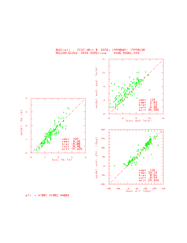
The WNA has run on the Cray C90 computer intermittently since August 1998 and continuously on the IBM since the beginning of June 1999. The adequacy of the model has been evaluated by comparing model output of the WNA and the ECGM with observed data at NDBC buoys. Figure 2 shows scatter plots of the significant wave height (Hs) produced by the WNA for +00 hr forecasts, respectively, for June 1999. Also shown are the following statistical indices: the mean bias error (bis), root Also presented are scatter plots and statistics for wind speed and direction. Similar results for the ECGM are given in Fig. 3. It should be noted that wind input to the ECGM is different from that of the WNA. Wind data used in ECGM are interpolated to the wave model grid from EDAS and eta data on the native 32 km grid mesh at 10m height.
Although the statistics for this model are only for June, 1999, we have the performance from the NWW3 global wave model which covers a 3 year period from 1997 through 1999 and the AKW regional wave model which covers from June 1998 to the present to draw upon since all three models are based on the NNW3, except that the bathymetry has been included and the resolution is much finer. The results of the comparison show that the WNA's predictions have less statistical error, less scattering and higher correlation with observations than the ECGM's which is consistent with the performance of the other wave models.
4. Available Products and Dissemination
The following wind and wave parameters are available in GRIB format at ftp://polar.ncep.noaa.gov/pub/waves, on Family of Services (FOS), on AFOS and facsimile circuits until they are retired, and on AWIPS as GRIB bulletins: Hs, Dm, Tm, peak wave period and direction, wind sea peak period and direction, wind speed and direction, and u- and v-wind components. Spectral text bulletins are also available on the web at the site above and will be on AWIPS as soon AWIPS headers are assigned.
a. GRIB bulletins
GRIB bulletins are available for use in AWIPS and for transmission on the Numerical Data Service of FOS. Table 2 gives the bulletin headers and their meaning. Bulletins are available at 6-h intervals from 00- through 72-h. Available parameters are Hs, Dm, Tm, peak wave period and direction, wind sea peak wave period and direction, and u and v components of the wind velocity. A 0.25 x 0.25 degree lon./lat. grid is used with a domain of 98.25oW - 29.75oW by 0.25oS - 50.25oN.
b. AFOS graphics products
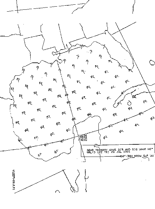
On AFOS, only the total significant wave height and the prevailing wave direction at selected grid points are transmitted. Figure 6 presents a sample AFOS chart. The arrows indicate the prevailing wave directions and the numerical values next to them indicate the total significant wave height in feet. These charts are transmitted twice daily at approximately 0515 UTC and 1735 UTC. They have also been converted to AWIPS graphics and are available in AWIPS as graphics only. The AFOS headers are:
NMCGPH6TY 00H GMX SWH PDR
NMCGPH6TY 12H GMX SWH PDR
NMCGPH6TY 24H GMX SWH PDR
NMCGPH6TY 36H GMX SWH PDR
NMCGPH6TY 48H GMX SWH PDR
c. DIFAX products
A graphic similar to one described for AFOS is available on DIFAX. The only difference is that the density of points displayed is increased. A five panel chart depicting wave direction and wave heights is sent out twice a day at 0708 UTC (slot D0140) and at 1827 UTC (slot 184). Each panel depicts the forecast guidance for 00-, 12-, 24-, 36-, and 48-h, respectively. Figure 7 shows a sample DIFAX chart. These graphics have also been converted to AWIPS and are available in AWIPS as graphics only.
d. Alphanumeric spectral messages
Spectral text bulletins are presented for numerous points of the WNA. These bulletins are in ASCII and are available on the INTERNET at present, and, when AWIPS headers are assigned, they will be available to the field on AWIPS. The line length of the table is 130 characters by 100 lines. The header of the table identifies the output location, the generating model and the run date and cycle of the data presented. At the bottom of the table, a legend is printed. The table consists of 8 columns. The first column gives the time of the model results with a day and hour (the corresponding month and year can be deduced from the header information. The second column presents the overall significant wave height (Hs), the number of individual wave fields with a wave height over 0.15 m that could not be tracked in the table (x). Individual wave fields in the spectrum are identified by using a partitioning scheme similar to that of Gerling (1992). In the remaining six columns individual wave fields identified with their wave height (Hs), peak wave period (Tp) and mean wave direction (dir, direction in which waves travel relative to North). Generally, each separate wave field is tracked in its own column. Such tracking, however is not guaranteed to work all the time. An asterisk (*) in a column identifies that the wave field is at least partially under the influence of the local wind, and, therefore, most likely part of the local wind sea. All other wave fields are pure swell.
5. References
Booij, N. and L.H. Holthuijsen, 1987: Propagation of ocean waves in discrete spectral wave models. J. Comput. Phys., 68, 307-326.
Caplan, P., J. Derber, W. Gemmill, S,-Y. Hong, H.-L. Pan and D. Parish, 1997: Changes to the NCEP operational medium-range forecast model analysis/forecast system. Wea. Forecasting, 12, 581-594.
Chalikov, D.V. and Belevich, M.Y., 1993: One-dimensional theory of the boundary layer. Boundary-Layer Meteor., 63, 65-96.
Chao, Y.Y., 1997: The U.S. East Coast-Gulf of Mexico wave forecasting model Technical Procedures Bulletin No. 446, National Weather Service, NOAA, U.S. Department of Commerce, 10 pp. [Available at http://www.nws.noaa.gov/om/tpbpr.htm; OBSOLETE]
Chen, H.S., L.D. Burroughs and H.L. Tolman, 1999: Ocean Surface Waves. Technical Procedures Bulletin No. 453, National Weather Service, NOAA, U.S. Department of Commerce. [Available at http://www.nws.noaa.gov/om/tpb/inddraft.htm]
Gerling, T.W., 1992: Partitioning sequences and arrays of directional wave spectra into component systems. J. Atmos. Ocean. Technol., 9, 444-458.
Grumbine, R.W., 1996: Automated passive microwave sea ice concentration analysis at NCEP. Ocean Modeling Branch Tech Note No. 120, NCEP, National Weather Service, NOAA, U.S. Department of Commerce, 13 pp.
Kanamitsu, M., J.C. Alpert, K.A. Campana, P.M. Caplan, D.G. Deaven, M. Iredell, B. Katz, H.-L. Pan, J.E. Sela and G. H. White, 1991: Recent Changes implemented into the global forecast system at NMC. Wea. Forecasting, 6, 425-435.
Tolman, H.L. and D. Chalikov, 1996: Source terms in a third-generation wind-wave model. J. Phys. Oceanogr., 26, 2497-2518.
Tolman, H.L., 1999a: User manual and system documentation of WAVEWATCH-III version 1.18. Technical Note No. 166, Ocean Modeling Branch, NCEP, National Weather Service, NOAA, U.S. Department of Commerce, 110 pp. [Available at http://polar.ncep.noaa.gov/waves/wavewatch/].
Tolman, H.L., 1999b: WAVEWATCH-III version 1.18: Generating GRIB files. Technical Note No. 167, Ocean Modeling Branch, NCEP, National Weather Service, NOAA, U.S. Department of Commerce, 7 pp. [Available at http://polar.ncep.noaa.gov/waves/wavewatch/].
Tolman, H.L., 1999c: WAVEWATCH-III version 1.18: Postprocessing using NCAR graphics. Technical Note No. 168, Ocean Modeling Branch, NCEP, National Weather Service, NOAA, U.S. Department of Commerce, 9 pp. [Available at http://polar.ncep.noaa.gov/waves/wavewatch/].
1. H. L. Tolman is a UCAR visiting scientist with the Ocean Modeling Branch
2. OMB Contribution No. 172